NAC Datasets
bb6635909m_2_1.nc
Dataset Overview
Project: Lankhorst, Matthias (2025). North Atlantic Current Time Series from Satellite and Float Observations (1993-2025).
Description: North Atlantic Current Time Series from Satellite and Float Observations (1993-2025)
Source File: bb6635909m_2_1.nc
Data Product: 6-monthly mean NAC transport time series (1993-2025) estimated from satellite and float observations
License: CC-BY-4.0
Date Created: 2025-10-07T00:00:00Z
Time Coverage: 1993-01-01 to 2025-07-02
Record Length: 66 observations (32.5 years)
Sampling Frequency: 6-monthly
Citation:
Lankhorst, Matthias (2025). North Atlantic Current Time Series from Satellite and Float Observations (1993-2025). In North Atlantic Current Time Series from Satellite and Float Observations. UC San Diego Library Digital Collections. https://doi.org/10.6075/J0D79CCG
Acknowledgement:
Earlier versions of this dataset were created with support from the European Commission through awards EVK2-CT-2000-00087 and EVR1-CT-2001-40014 (projects ‘GYROSCOPE’ and ‘ANIMATE’). Updated versions were partially supported through award NA15OAR4320071 from U.S. NOAA OOMD.
Dataset Visualization
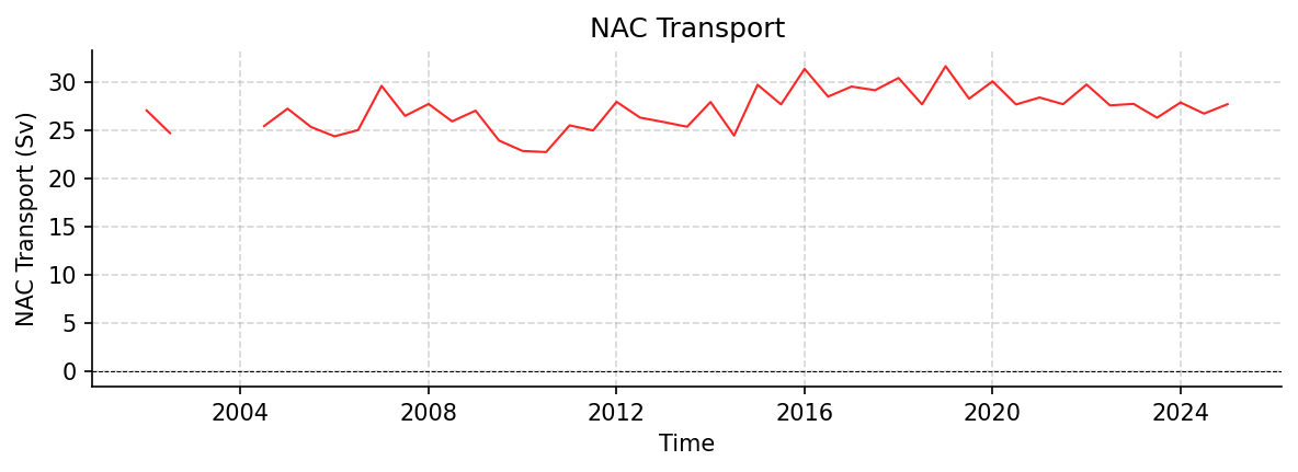
Time series plot for NAC dataset.
Dataset Statistics
Total Variables: 8
Total Coordinates: 4
Dataset Size: 0.00 MB
Coordinate Information
The following table shows information about the dataset coordinates in the standardised version, including coordinate name remapping from the original, if any:
Coordinate |
Description |
Units |
Size |
Min Value |
Max Value |
Missing % |
|---|---|---|---|---|---|---|
DEPTH_SECTION_MIDPOINT |
No description available |
m |
(1,) |
494.90 |
494.90 |
0.0% |
LATITUDE_SECTION_MIDPOINT |
No description available |
degree_north |
(1,) |
54.90 |
54.90 |
0.0% |
LONGITUDE_SECTION_MIDPOINT |
No description available |
degree_east |
(1,) |
-26.56 |
-26.56 |
0.0% |
TIME |
Time |
seconds since 1970-01-01T00:00:00Z |
(66,) |
1993-01-01 |
2025-07-02 |
0.0% |
Variable Information
The following table shows the mapping from original variable names to standardized names, along with key statistics for each variable.
Variable |
Description |
Units |
Size |
Min Value |
Max Value |
Missing % |
|---|---|---|---|---|---|---|
GEOMETRY |
No description available |
unknown |
() |
0.00 |
0.00 |
0.0% |
GEOMETRY_NODES_DEPTH |
No description available |
m |
(4,) |
0.00 |
988.61 |
0.0% |
GEOMETRY_NODES_LATITUDE |
No description available |
degree_north |
(4,) |
49.00 |
59.70 |
0.0% |
GEOMETRY_NODES_LONGITUDE |
No description available |
degree_east |
(4,) |
-39.70 |
-16.50 |
0.0% |
GEOMETRY_NODE_COUNT |
No description available |
unknown |
(1,) |
4.00 |
4.00 |
0.0% |
NAC → TRANS_NAC |
NAC Transport: North Atlantic Current transport time series from satellite and float observations |
sverdrup |
(66, 1) |
22.74 |
31.65 |
33.3% |
NAC_PROXY → TRANS_NAC_PROXY |
NAC Transport Proxy: Proxy for North Atlantic Current transport time series from satellite altimetry |
sverdrup |
(66, 1) |
23.30 |
30.63 |
0.0% |
NAC_UNCERTAINTY → TRANS_NAC_UNCERTAINTY |
Uncertainty of values in NAC variable: Uncertainty of North Atlantic Current transport time series |
sverdrup |
(66, 1) |
1.47 |
2.17 |
33.3% |
Metadata (edits applied noted)
The following metadata describes this dataset:
Title: North Atlantic Current Time Series from Satellite and Float Observations
Summary: The North Atlantic Current (NAC) is the continuation of the Gulf Stream on its path towards Europe. Here, a time series of its strength is reported that is calculated from two observational datasets: One is the sea surface height from satellite altimetry, the other consists of watercolumn temperature and salinity profiles from Argo floats. The NAC flow is given as the total volume transport of water in a depth layer defined by pressure ranges of 0 - 1000 dbar, across a section that spans from a site in the Central Irminger Sea (CIS) to another in the Porcupine Abyssal Plain (PAP) area. Uncertainty estimates of the flow are included, as is a proxy time series of longer duration that is estimated from satellite data alone. The corresponding variables in this file are NAC and NAC_UNCERTAINTY for the main volume transport time series and its uncertainy, and NAC_PROXY for the satellite-only time series. The methodology is described in a publication by Lankhorst and Send (Progress in Oceanography, 2020; see ‘references’); the data here represent an updated version of what is shown in figure 6a of this publication.
Description*: North Atlantic Current Time Series from Satellite and Float Observations (1993-2025)
Program*: NAC
Project*: Lankhorst, Matthias (2025). North Atlantic Current Time Series from Satellite and Float Observations (1993-2025).
License: CC-BY-4.0
Acknowledgment*: Earlier versions of this dataset were created with support from the European Commission through awards EVK2-CT-2000-00087 and EVR1-CT-2001-40014 (projects ‘GYROSCOPE’ and ‘ANIMATE’). Updated versions were partially supported through award NA15OAR4320071 from U.S. NOAA OOMD.
References: https://doi.org/10.1016/j.pocean.2020.102402 https://doi.org/10.21941/E8RT-MQ80 https://doi.org/10.48670/moi-00148 https://doi.org/10.48670/moi-00149 https://doi.org/10.48670/moi-00150 https://doi.org/10.17882/42182#121877
Data Product*: 6-monthly mean NAC transport time series (1993-2025) estimated from satellite and float observations
Time Coverage Start: 1993-01-01
Time Coverage End: 2025-07-02
Geospatial Lat Min: 49.0
Geospatial Lat Max: 59.7
Geospatial Lon Min: -39.7
Geospatial Lon Max: -16.5
Geospatial Vertical Min: 0.0
Geospatial Vertical Max: 1000.0
Contributor Name: Matthias Lankhorst
Contributor Role: originator
Contributor Role Vocabulary: https://vocab.nerc.ac.uk/collection/G04/current/
Contributor Email:
Contributor Id: https://orcid.org/0000-0002-4166-4044
Contributing Institutions: Scripps Institution of Oceanography
Contributing Institutions Vocabulary: https://edmo.seadatanet.org/report/1390
Contributing Institutions Role:
Conventions: CF-1.12, ACDD-1.3, OceanSITES-1.5
Standard Name Vocabulary: CF Standard Name Table v92
featureType*: timeSeries
featureType_vocabulary: https://cfconventions.org/cf-conventions/v1.6.0/cf-conventions.html#_features_and_feature_types
Source File*: bb6635909m_2_1.nc
Source Path*: ~/.amocatlas_data/bb6635909m_2_1.nc
Source Url*: https://library.ucsd.edu/dc/object/bb6635909m/
Date Created: 2025-10-07T00:00:00Z
Date Modified: 2026-09-01T00:00:00Z
Processing Software: http://github.com/AMOCcommunity/amocatlas
Processing Version: v0.4.0
Processing Datasource*: nac
Applied Variable Mapping: {‘NAC’: ‘TRANS_NAC’, ‘NAC_UNCERTAINTY’: ‘TRANS_NAC_UNCERTAINTY’, ‘NAC_PROXY’: ‘TRANS_NAC_PROXY’}
Keywords: geostrophic current, North Atlantic Current, altimetry, Argo, Irminger Sea, Porcupine Abyssal Plain
Geospatial Vertical Units: dbar
Geospatial Vertical Positive: down