WH41N Datasets
This report covers all available WH41N datasets.
hobbs_willis_amoc41N_tseries.txt
Dataset Overview
Project: Atlantic Meridional Overturning Circulation Near 41N from Altimetry and Argo Observations
Description: 41N transport estimates dataset
Source File: hobbs_willis_amoc41N_tseries.txt
Data Product: Atlantic Meridional Overturning Circulation Near 41N from Altimetry and Argo Observations
License: CC-BY-4.0
Time Coverage: 2002-01-16 to 2025-12-16
Record Length: 288 observations (23.9 years)
Sampling Frequency: monthly
Citation:
Willis, J. K., and Hobbs, W. R., Atlantic Meridional Overturning Circulation Near 41N from Altimetry and Argo Observations. Dataset accessed at 10.5281/zenodo.8170365.
Dataset Visualization
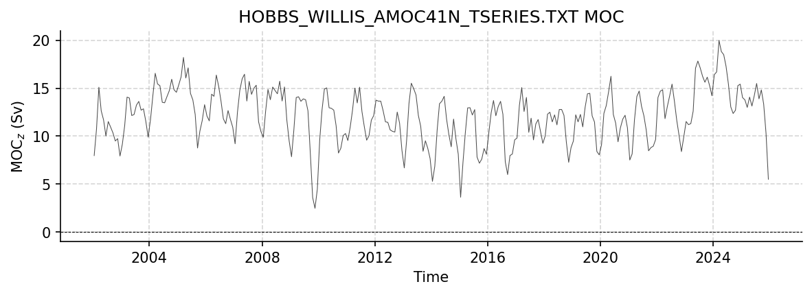
Time series plot for HOBBS_WILLIS_AMOC41N_TSERIES.TXT dataset.
Dataset Statistics
Total Variables: 4
Total Coordinates: 1
Dataset Size: 0.01 MB
Coordinate Information
The following table shows information about the dataset coordinates in the standardised version, including coordinate name remapping from the original, if any:
Coordinate |
Description |
Units |
Size |
Min Value |
Max Value |
Missing % |
|---|---|---|---|---|---|---|
TIME |
Time |
datetime64[ns] |
(288,) |
2002-01-16 |
2025-12-16 |
0.0% |
Variable Information
The following table shows the mapping from original variable names to standardized names, along with key statistics for each variable.
Variable |
Description |
Units |
Size |
Min Value |
Max Value |
Missing % |
|---|---|---|---|---|---|---|
MOC (PW) → MHT |
MHT: Meridional Overturning Heat Transport |
PW |
(288,) |
-0.04 |
0.94 |
0.0% |
MOC (Sv) → MOC |
MOC_z: Meridional Overturning Volume Transport |
Sverdrup |
(288,) |
2.47 |
19.98 |
0.0% |
Ekman (Sv) → TRANS_EKMAN |
Ekman: Ekman Volume Transport |
Sverdrup |
(288,) |
-8.79 |
0.51 |
0.0% |
Geos (Sv) → TRANS_GEO |
Geostrophic Transport: Northward Geostrophic Transport |
Sverdrup |
(288,) |
6.16 |
23.96 |
0.0% |
Metadata (edits applied noted)
The following metadata provides comprehensive information about this dataset:
Summary: 41N transport estimates dataset
Description*: 41N transport estimates dataset
Program*: 41N
Project*: Atlantic Meridional Overturning Circulation Near 41N from Altimetry and Argo Observations
License*: CC-BY-4.0
Weblink*: https://doi.org/10.5281/zenodo.8170365
Platform: Argo floats
Platform Vocabulary: https://vocab.nerc.ac.uk/collection/L06/
Data Product*: Atlantic Meridional Overturning Circulation Near 41N from Altimetry and Argo Observations
Contributor Name*: Will Hobbs, Josh K. Willis
Contributor Role*: originator, principalInvestigator
Contributor Role Vocabulary: https://vocab.nerc.ac.uk/collection/G04/current/
Contributor Email: ,
Contributor Id: https://orcid.org/0000-0002-2061-0899, https://orcid.org/0000-0002-4515-8771
Contributing Institutions*: National Aeronautics and Space Administration - Jet Propulsion Laboratory (NASA JPL)
Contributing Institutions Vocabulary: https://edmo.seadatanet.org/report/1224
Contributing Institutions Role:
Conventions*: CF-1.8, ACDD-1.3, OceanSITES-1.5
featureType*: timeSeries
featureType_vocabulary: https://cfconventions.org/cf-conventions/v1.6.0/cf-conventions.html#_features_and_feature_types
Source File*: hobbs_willis_amoc41N_tseries.txt
Source Path*: ~/AMOCatlas/data/hobbs_willis_amoc41N_tseries.txt
Source Url*: https://doi.org/10.5281/zenodo.8170365
Date Modified: 2026-02-01T00:00:00Z
Processing Software: http://github.com/AMOCcommunity/amocatlas
Processing Version: v0.3.0
Processing Datasource*: wh41n
Variable Mapping*: {‘Ekman (Sv)’: ‘TRANS_EKMAN’, ‘Geos (Sv)’: ‘TRANS_GEO’, ‘MOC (Sv)’: ‘MOC’, ‘MOC (PW)’: ‘MHT’}
Original Variable Metadata*: [Complex metadata structure - 4 items]
Applied Variable Mapping: {‘Ekman (Sv)’: ‘TRANS_EKMAN’, ‘Geos (Sv)’: ‘TRANS_GEO’, ‘MOC (Sv)’: ‘MOC’, ‘MOC (PW)’: ‘MHT’}
Version*: v5
trans_ARGO_ERA5.nc
Dataset Overview
Project: Atlantic Meridional Overturning Circulation Near 41N from Altimetry and Argo Observations
Description: 41N transport estimates dataset
Source File: trans_ARGO_ERA5.nc
Data Product: Transport components from ARGO and ERA5
License: CC-BY-4.0
Date Created: Mon 12 Jan 2026 14:06:47 AEDT
Time Coverage: 2002-01-15 to 2025-12-15
Record Length: 288 observations (23.9 years)
Sampling Frequency: monthly
Citation:
Willis, J. K., and Hobbs, W. R., Atlantic Meridional Overturning Circulation Near 41N from Altimetry and Argo Observations. Dataset accessed at 10.5281/zenodo.8170365.
Dataset Visualization
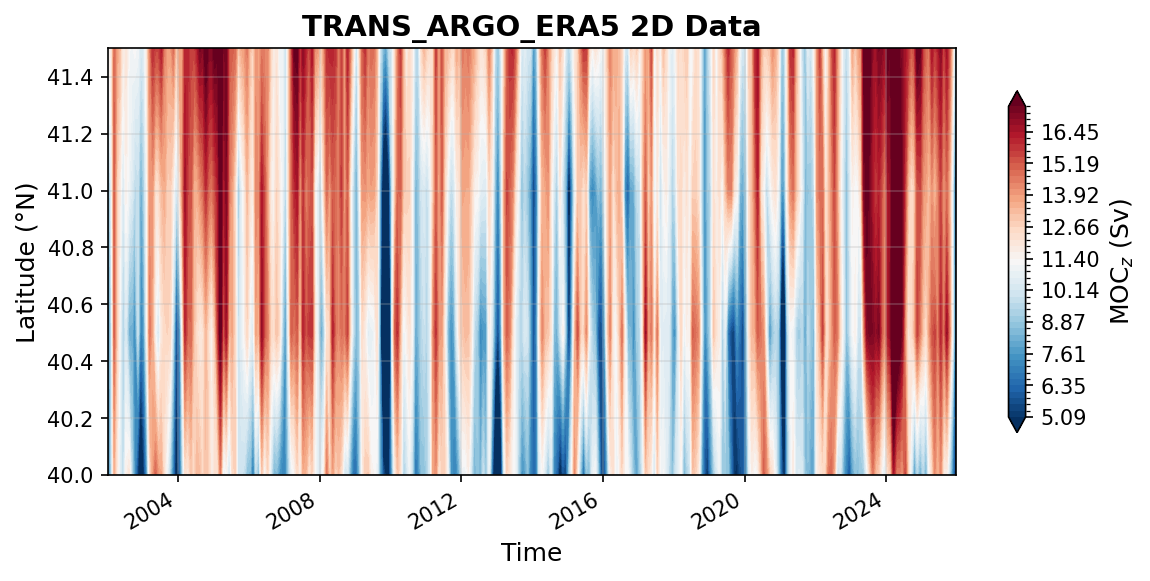
Time series plot for TRANS_ARGO_ERA5 dataset.
Dataset Statistics
Total Variables: 3
Total Coordinates: 4
Dataset Size: 282.67 MB
Coordinate Information
The following table shows information about the dataset coordinates in the standardised version, including coordinate name remapping from the original, if any:
Coordinate |
Description |
Units |
Size |
Min Value |
Max Value |
Missing % |
|---|---|---|---|---|---|---|
depth → DEPTH |
Depth: Depth below surface of the water |
m |
(201,) |
0.00 |
2000.00 |
0.0% |
lat → LATITUDE |
Latitude: Latitude north (WGS84) |
degree_north |
(4,) |
40.00 |
41.50 |
0.0% |
lon → LONGITUDE |
Longitude: Longitude east (WGS84) |
degree_east |
(320,) |
280.12 |
359.88 |
0.0% |
TIME |
Time |
datetime64[ns] |
(288,) |
2002-01-15 |
2025-12-15 |
0.0% |
Variable Information
The following table shows the mapping from original variable names to standardized names, along with key statistics for each variable.
Variable |
Description |
Units |
Size |
Min Value |
Max Value |
Missing % |
|---|---|---|---|---|---|---|
moc → MOC |
MOC_z: Overturning circulation transport |
Sverdrup |
(288, 4) |
-4.78 |
20.74 |
0.0% |
trans → TRANS_GEO |
Geostrophic transport: Observed geostrophic transport from ARGO |
Sverdrup |
(288, 4, 320, 201) |
-0.18 |
0.19 |
26.2% |
Vek → VEL_EKMAN |
Ekman: Ekman transport from ERA5 reanalysis |
Sverdrup |
(288, 4) |
-8.99 |
0.73 |
0.0% |
Metadata (edits applied noted)
The following metadata provides comprehensive information about this dataset:
Title: transport from ARGO/SSH data
Summary: 41N transport estimates dataset
Description*: 41N transport estimates dataset
Program*: 41N
Project*: Atlantic Meridional Overturning Circulation Near 41N from Altimetry and Argo Observations
License*: CC-BY-4.0
Weblink*: https://doi.org/10.5281/zenodo.8170365
Platform: Argo floats
Platform Vocabulary: https://vocab.nerc.ac.uk/collection/L06/
Data Product*: Transport components from ARGO and ERA5
Contributor Name*: Will Hobbs, Josh K. Willis
Contributor Role*: originator, principalInvestigator
Contributor Role Vocabulary: https://vocab.nerc.ac.uk/collection/G04/current/
Contributor Email: ,
Contributor Id: https://orcid.org/0000-0002-2061-0899, https://orcid.org/0000-0002-4515-8771
Contributing Institutions*: National Aeronautics and Space Administration - Jet Propulsion Laboratory (NASA JPL)
Contributing Institutions Vocabulary: https://edmo.seadatanet.org/report/1224
Contributing Institutions Role:
Conventions*: CF-1.8, ACDD-1.3, OceanSITES-1.5
Source File*: trans_ARGO_ERA5.nc
Source Path*: ~/AMOCatlas/data/trans_ARGO_ERA5.nc
Source Url*: https://doi.org/10.5281/zenodo.8170365
Date Created: Mon 12 Jan 2026 14:06:47 AEDT
Date Modified: 2026-02-01T00:00:00Z
Processing Software: http://github.com/AMOCcommunity/amocatlas
Processing Version: v0.3.0
Processing Datasource*: wh41n
Variable Mapping*: {‘Vek’: ‘VEL_EKMAN’, ‘trans’: ‘TRANS_GEO’, ‘moc’: ‘MOC’, ‘depth’: ‘DEPTH’, ‘lat’: ‘LATITUDE’, ‘lon’: ‘LONGITUDE’}
Original Variable Metadata*: [Complex metadata structure - 3 items]
Applied Variable Mapping: {‘Vek’: ‘VEL_EKMAN’, ‘trans’: ‘TRANS_GEO’, ‘moc’: ‘MOC’, ‘depth’: ‘DEPTH’, ‘lat’: ‘LATITUDE’, ‘lon’: ‘LONGITUDE’, ‘MOC’: ‘MOC’, ‘DEPTH’: ‘DEPTH’}
Reference Temp: kelvin
Wind Stress: ERA5
Q_ARGO_obs_dens_2000depth_ERA5.nc
Dataset Overview
Project: Atlantic Meridional Overturning Circulation Near 41N from Altimetry and Argo Observations
Description: 41N transport estimates dataset
Source File: Q_ARGO_obs_dens_2000depth_ERA5.nc
Data Product: Heat transport based on various assumptions about temperature below 2000m
License: CC-BY-4.0
Date Created: Mon 12 Jan 2026 14:06:47 AEDT
Time Coverage: 2002-01-15 to 2025-12-15
Record Length: 288 observations (23.9 years)
Sampling Frequency: monthly
Citation:
Willis, J. K., and Hobbs, W. R., Atlantic Meridional Overturning Circulation Near 41N from Altimetry and Argo Observations. Dataset accessed at 10.5281/zenodo.8170365.
Dataset Visualization
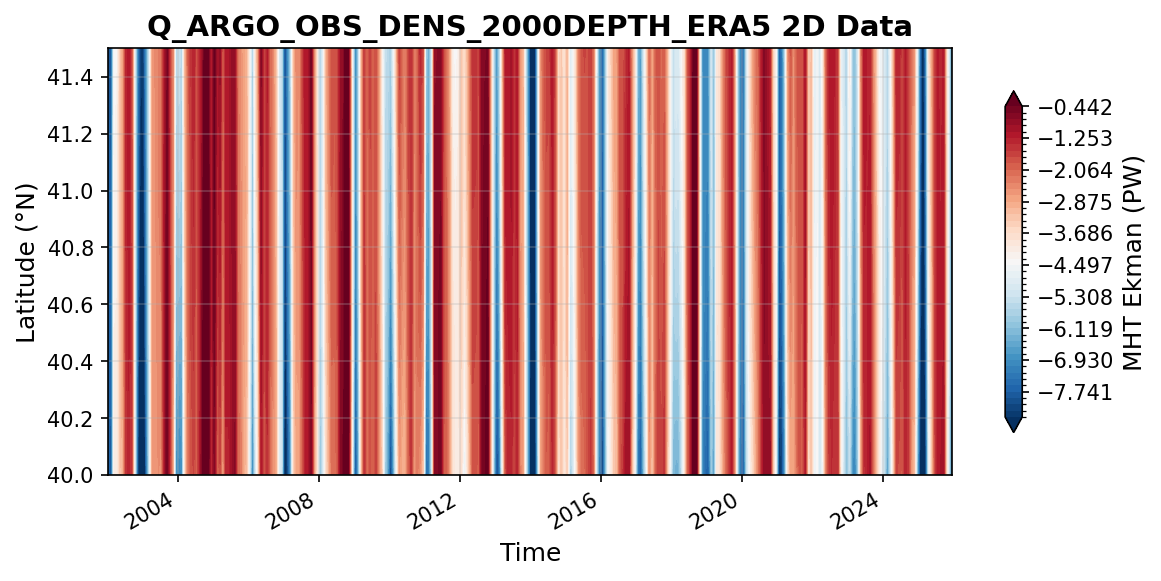
Time series plot for Q_ARGO_OBS_DENS_2000DEPTH_ERA5 dataset.
Dataset Statistics
Total Variables: 3
Total Coordinates: 5
Dataset Size: 282.68 MB
Coordinate Information
The following table shows information about the dataset coordinates in the standardised version, including coordinate name remapping from the original, if any:
Coordinate |
Description |
Units |
Size |
Min Value |
Max Value |
Missing % |
|---|---|---|---|---|---|---|
depth → DEPTH |
Depth: Depth below surface of the water |
m |
(201,) |
0.00 |
2000.00 |
0.0% |
Hpar |
deep ocean volumetric Heat |
J/m^3 |
(4,) |
1115000064.00 |
1129299968.00 |
0.0% |
lat → LATITUDE |
Latitude: Latitude north (WGS84) |
degree_north |
(4,) |
40.00 |
41.50 |
0.0% |
lon → LONGITUDE |
Longitude: Longitude east (WGS84) |
degree_east |
(320,) |
280.12 |
359.88 |
0.0% |
TIME |
Time |
datetime64[ns] |
(288,) |
2002-01-15 |
2025-12-15 |
0.0% |
Variable Information
The following table shows the mapping from original variable names to standardized names, along with key statistics for each variable.
Variable |
Description |
Units |
Size |
Min Value |
Max Value |
Missing % |
|---|---|---|---|---|---|---|
Q → MHT |
MHT: Observed meridional heat transport |
PW |
(288, 4, 320, 201) |
-0.22 |
0.24 |
26.2% |
Qek → MHT_EKMAN |
MHT Ekman: Ekman meridional heat transport |
PW |
(288, 4) |
-10.55 |
0.88 |
0.0% |
Qnet → MHT_NET |
Net heat transport: Net meridional heat transport |
PW |
(288, 4, 4) |
-0.54 |
1.21 |
0.0% |
Metadata (edits applied noted)
The following metadata provides comprehensive information about this dataset:
Title: heat transport from ARGO/SSH data
Summary: 41N transport estimates dataset
Description*: 41N transport estimates dataset
Program*: 41N
Project*: Atlantic Meridional Overturning Circulation Near 41N from Altimetry and Argo Observations
License*: CC-BY-4.0
Weblink*: https://doi.org/10.5281/zenodo.8170365
Platform: Argo floats
Platform Vocabulary: https://vocab.nerc.ac.uk/collection/L06/
Data Product*: Heat transport based on various assumptions about temperature below 2000m
Contributor Name*: Will Hobbs, Josh K. Willis
Contributor Role*: originator, principalInvestigator
Contributor Role Vocabulary: https://vocab.nerc.ac.uk/collection/G04/current/
Contributor Email: ,
Contributor Id: https://orcid.org/0000-0002-2061-0899, https://orcid.org/0000-0002-4515-8771
Contributing Institutions*: National Aeronautics and Space Administration - Jet Propulsion Laboratory (NASA JPL)
Contributing Institutions Vocabulary: https://edmo.seadatanet.org/report/1224
Contributing Institutions Role:
Conventions*: CF-1.8, ACDD-1.3, OceanSITES-1.5
Source File*: Q_ARGO_obs_dens_2000depth_ERA5.nc
Source Path*: ~/AMOCatlas/data/Q_ARGO_obs_dens_2000depth_ERA5.nc
Source Url*: https://doi.org/10.5281/zenodo.8170365
Date Created: Mon 12 Jan 2026 14:06:47 AEDT
Date Modified: 2026-02-01T00:00:00Z
Processing Software: http://github.com/AMOCcommunity/amocatlas
Processing Version: v0.3.0
Processing Datasource*: wh41n
Variable Mapping*: {‘Qnet’: ‘MHT_NET’, ‘Qek’: ‘MHT_EKMAN’, ‘Q’: ‘MHT’, ‘depth’: ‘DEPTH’, ‘lat’: ‘LATITUDE’, ‘lon’: ‘LONGITUDE’, ‘time’: ‘TIME’}
Original Variable Metadata*: [Complex metadata structure - 3 items]
Applied Variable Mapping: {‘Qnet’: ‘MHT_NET’, ‘Qek’: ‘MHT_EKMAN’, ‘Q’: ‘MHT’, ‘depth’: ‘DEPTH’, ‘lat’: ‘LATITUDE’, ‘lon’: ‘LONGITUDE’, ‘DEPTH’: ‘DEPTH’, ‘TIME’: ‘TIME’}
Reference Temp: kelvin
Wind Stress: ERA5