SF2021 Datasets
altimetry_moc_transport_1993_2020_18mos_smoothed.nc
Dataset Overview
Project: Satellite proxy for the AMOC at 26N
Description: A dynamically based method for estimating the Atlantic meridional overturning circulation at 26°N from satellite altimetry
Source File: altimetry_moc_transport_1993_2020_18mos_smoothed.nc
Data Product: A dynamically based method for estimating the Atlantic meridional overturning circulation at 26°N from satellite altimetry
License: CC-BY-4.0
Time Coverage: 1993-01-17 to 2018-12-17
Record Length: 312 observations (25.9 years)
Sampling Frequency: monthly
Citation:
Sanchez-Franks, A., Frajka-Williams, E., Moat, B. I., and Smeed, D. A.: A dynamically based method for estimating the Atlantic meridional overturning circulation at 26°N from satellite altimetry, Ocean Sci., 17, 1321-1340, https://doi.org/10.5194/os-17-1321-2021, 2021
Acknowledgement:
The authors thank the reviewers for their helpful comments. The authors also thank the many officers, crew, and technicians who helped to collect these data. Alejandra Sanchez-Franks also thanks Louis Clément for helpful discussions on normal-mode decomposition. This research has been supported by grants from the UK Natural Environment Research Council for the RAPID-AMOC programme and the ACSIS programme (grant no. NE/N018044/1) as well as funding from the European Union Horizon 2020 Research and Innovation programme BLUE-ACTION (grant no. 727852).
Dataset Visualization
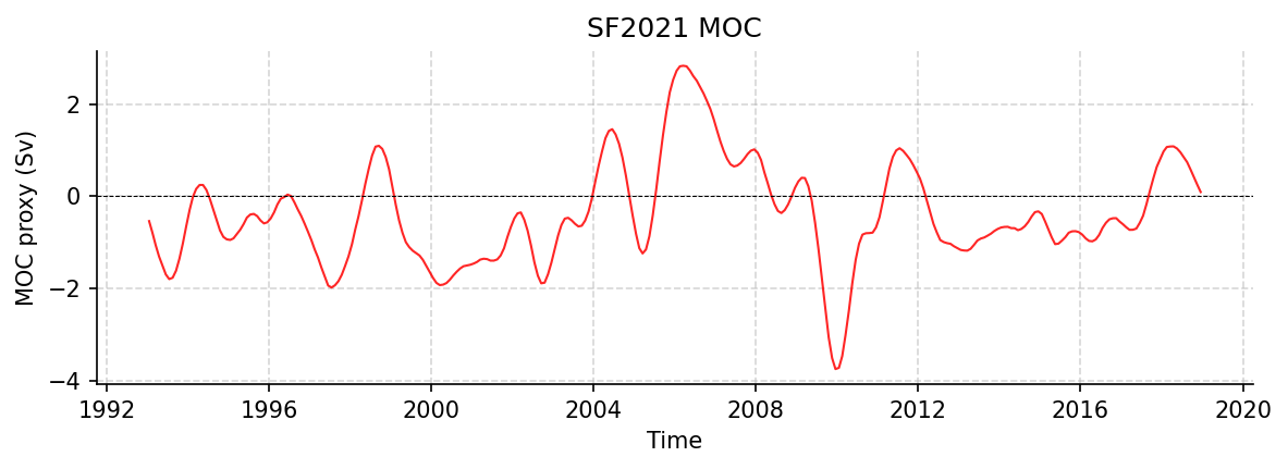
Time series plot for SF2021 dataset.
Dataset Statistics
Total Variables: 3
Total Coordinates: 1
Dataset Size: 0.01 MB
Coordinate Information
The following table shows information about the dataset coordinates in the standardised version, including coordinate name remapping from the original, if any:
Coordinate |
Description |
Units |
Size |
Min Value |
Max Value |
Missing % |
|---|---|---|---|---|---|---|
sat_time → TIME |
Time |
seconds since 1970-01-01T00:00:00Z |
(312,) |
1993-01-17 |
2018-12-17 |
0.0% |
Variable Information
The following table shows the mapping from original variable names to standardized names, along with key statistics for each variable.
Variable |
Description |
Units |
Size |
Min Value |
Max Value |
Missing % |
|---|---|---|---|---|---|---|
sat_moc_filt → MOC_PROXY |
MOC proxy: constructed by adding the satellite-derived TRANS_GS and TRANS_UMO with the TRANS_EK, obtained from ERA5 wind stress |
sverdrup |
(312,) |
-3.76 |
2.83 |
0.0% |
sat_gs_filt → TRANS_GS_PROXY |
Gulf Stream / Florida Current: The strength of the Gulf Stream transport through the Florida Straits between Florida and Bahamas, as measured by a submarine telephone cable. |
sverdrup |
(312,) |
-0.64 |
1.09 |
0.0% |
sat_umo_filt → TRANS_UMO_PROXY |
UMO proxy: sum of the western boundary wedge transport, the hypsometric mass compensation, and the internal geostrophic transport over the top 1100 m |
sverdrup |
(312,) |
-2.37 |
3.20 |
0.0% |
Metadata (edits applied noted)
The following metadata describes this dataset:
Summary: A dynamically based method for estimating the Atlantic meridional overturning circulation at 26°N from satellite altimetry
Description*: A dynamically based method for estimating the Atlantic meridional overturning circulation at 26°N from satellite altimetry
Project*: Satellite proxy for the AMOC at 26N
License*: CC-BY-4.0
Acknowledgment*: The authors thank the reviewers for their helpful comments. The authors also thank the many officers, crew, and technicians who helped to collect these data. Alejandra Sanchez-Franks also thanks Louis Clément for helpful discussions on normal-mode decomposition. This research has been supported by grants from the UK Natural Environment Research Council for the RAPID-AMOC programme and the ACSIS programme (grant no. NE/N018044/1) as well as funding from the European Union Horizon 2020 Research and Innovation programme BLUE-ACTION (grant no. 727852).
Weblink*: https://zenodo.org/records/18941523
Data Product*: A dynamically based method for estimating the Atlantic meridional overturning circulation at 26°N from satellite altimetry
Time Coverage Start*: 1993-01-17
Time Coverage End*: 2018-12-17
Contributor Name*: Alejandra Sanchez-Franks
Contributor Role*: originator
Contributor Role Vocabulary*: https://vocab.nerc.ac.uk/collection/G04/current/
Contributor Email:
Contributor Id:
Contributing Institutions*: National Oceanographic Centre
Contributing Institutions Vocabulary:
Contributing Institutions Role:
Conventions*: CF-1.8, ACDD-1.3, OceanSITES-1.5
featureType*: timeSeries
featureType_vocabulary: https://cfconventions.org/cf-conventions/v1.6.0/cf-conventions.html#_features_and_feature_types
Source File*: altimetry_moc_transport_1993_2020_18mos_smoothed.nc
Source Path*: ~/.amocatlas_data/altimetry_moc_transport_1993_2020_18mos_smoothed.nc
Source Url*: https://zenodo.org/records/18941523/files/altimetry_moc_transport_1993_2020_18mos_smoothed.nc
Date Modified: 2026-08-01T00:00:00Z
Processing Software: http://github.com/AMOCcommunity/amocatlas
Processing Version: v0.4.0
Processing Datasource*: sf2021
Applied Variable Mapping: {‘sat_time’: ‘TIME’, ‘sat_moc_filt’: ‘MOC_PROXY’, ‘sat_umo_filt’: ‘TRANS_UMO_PROXY’, ‘sat_gs_filt’: ‘TRANS_GS_PROXY’}